Alberto

Alberto Makes Landfall, Brings Heavy Rains to Parts of the Southeast and Tennessee Valley

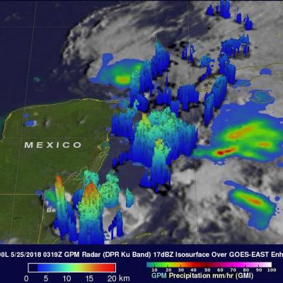
Alberto formed out of a broad area of low pressure at the surface that was located over and around the Yucatan Peninsula. Because the area of low pressure was under the influence of a nearby upper-level trough, Alberto was designated as a subtropical storm by the National Hurricane Center (NHC) on the morning of Friday May 25th, which is rather unusual as most subtropical storms form at higher latitudes. The storm initially formed just east of the Yucatan Peninsula. A large subtropical ridge over the southwestern Atlantic steered Alberto on a northward track, and the storm brushed the far

GPM Examines Forming Subtropical Storm Alberto

At 10:00 AM CDT today the National Hurricane Center (NHC) upgraded low pressure center (90L) to Subtropical Storm Alberto. Alberto moved over the waters of the northwestern Caribbean Sea. Alberto is expected to bring heavy rainfall and flash flooding to the northeastern Yucatan, western Cuba and Florida over the Memorial Day weekend. The GPM core observatory satellite passed above the Yucatan Peninsula on May 24, 2018 a 11:19 PM EDT (May 25, 2018 at 0319 UTC). With this pass GPM saw areas of heavy precipitation within the western Caribbean and in the Gulf Of Mexico west of Cuba. GPM's Dual

2012 Western Atlantic Tropical Cyclone Rainfall Measured From Space

The TRMM satellite has now been making highly accurate measurements of rainfall from space for fifteen years. TRMM can be used to calibrate rainfall estimates from other additional satellites. Those Rainfall data (3B42) are routinely created and stored at the Goddard Space Flight Center. The TRMM-based, near-real time Multi-satellite Precipitation Analysis (TMPA) at the NASA Goddard Space Flight Center can be used to analyze rainfall over a wide portion of the globe. The TMPA analysis above shows the estimated amount of rain contributed by named tropical cyclones over the western Atlantic in

Tropical Cyclone Season Gets Started in the Northern Hemisphere

Summer has not yet arrived, and yet there are currently 3 active tropical systems in the Northern Hemisphere spread across three different ocean basins. Perhaps, the most unusual of the three is Tropical Storm Alberto in the Atlantic. Alberto formed in the western Atlantic from a stationary low pressure system off of the coast of South Carolina on the 19th of May 2012, two weeks before the official June 1st start of the Atlantic hurricane season. Alberto is the first tropical storm to form this early in the season since Tropical Storm Ana in 2003, which formed on the 20th of April west of

TRMM Sees First Atlantic Tropical Storm Forming

The TRMM satellite flew above tropical storm Alberto when it was forming off the coast of South Carolina today. TRMM Microwave Imager (TMI) and Precipitation Radar (PR) data captured at (12 minutes after midnight EDT) were used in the rainfall analysis shown above. It shows a large area of moderate to heavy rainfall with a small area of heavy rainfall located near the center of the forming tropical cyclone.