GPM News

Updates to the GPM mission's status.

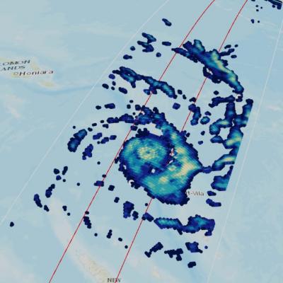
GPM Flies Over Category 4 Cyclone Harold in the South Pacific

For more information or to download this public domain video, go to: https://svs.gsfc.nasa.gov/4812#29226 UPDATE 4/9/2020 This animation shows the heavy precipitation associated with Tropical Cyclone Harold as it progressed from the Solomon Islands (upper left) on April 2, 2020, explosively intensified on April 3, reached Vanuatu (center) as a Category 4 storm on April 5 before briefly attaining Category 5 status on April 6 and passing just south of Fiji (center right) on April 7 as a Category 4 storm. Periodically, Harold's core region produced precipitation rates in excess of 30 millimeters

TRMM Spacecraft Re-enters Over Tropics

The Tropical Rainfall Measuring Mission (TRMM) spacecraft re-entered the Earth’s atmosphere on June 15, 2015, at 11:55 p.m. EDT, over the South Indian Ocean, according to the U.S. Strategic Command’s Joint Functional Component Command for Space through the Joint Space Operations Center (JSpOC). The U.S. Space Surveillance Network, operated by the Defense Department's JSpOC, had been closely monitoring TRMM’s descent since the mission was ended in April. Most of the spacecraft was expected to burn up in the atmosphere during its uncontrolled re-entry. This U.S. Air Force map shows the

Updated GPM Radiometer Products

The Precipitation Processing System (PPS) has begun producing updated GPM radiometer products as of 12/4/2014 due to an error discovered in the calculation of the Sun Angle in the PPS Geolocation Toolkit. This is considered a minor update with the Product Version being incremented in letter only. Please see the list of affected products here: http://pps.gsfc.nasa.gov/Documents/GPM_PPS_SunAngle_Products_20141204.p… For most radiometers the sun angle is used as ancillary information, but for the TRMM microwave imager (TMI) the correction also slightly impacts brightness temperature and

TRMM Precipitation Radar Data Suspended

The TRMM satellite is descending, and the users of TRMM Precipitation Radar (PR) data should be aware that the last production orbit of public PR data was orbit #96230 from October 7th, 2014. From that point forward, the TRMM PR data is suspended because no useful cloud data are being observed. It is possible that PR data will again be made available when TRMM descends to the vicinity of its at-launch altitude of 350 km. TRMM Microwave Imager (TMI) data will continue to be produced and publicly available during the descent of the spacecraft until it reaches its decommissioning altitude of

GPM Data Goes Public

The most accurate and comprehensive collection of rain, snowfall and other types of precipitation data ever assembled now is available to the public. This new resource for climate studies, weather forecasting, and other applications is based on observations by the Global Precipitation Measurement (GPM) Core Observatory, a joint mission of NASA and the Japan Aerospace Exploration Agency (JAXA), with contributions from a constellation of international partner satellites. The GPM Core Observatory, launched from Japan on Feb. 27, carries two advanced instruments to measure rainfall, snowfall, ice

TRMM Satellite Out of Station-keeping Fuel

Since December 1997, TRMM and the instruments it carries have provided valuable information to researchers, the applications community, and the public. On July 8, 2014, pressure readings from the fuel tank indicated that TRMM is at the end of its fuel. As a result, NASA has ceased station keeping maneuvers and TRMM has begun its drift downward from its operating altitude of 402 km. A small amount of fuel has been retained to conduct debris avoidance maneuvers to ensure the satellite remains safe during the drift down. TRMM observations will continue as the spacecraft descends to 335 km, at

Level 2 GPM Microwave Imager (GMI) Data Released

The Global Precipitation Measurement (GPM) mission's Precipitation Processing System at NASA’s Goddard Space Flight Center in Greenbelt, Maryland, has released the Level 2 GPM Microwave Imager (GMI) data to the public. The data set includes precipitation rates, which show how much rain and snowfall accumulate over a given time period. This Level 2 data set of falling rain and snow is computed from Level 1 brightness temperature observations from GMI, the basic measurement made by the instrument of naturally occurring energy radiated, in this case, by precipitation particles (raindrops or

GPM Data Release Schedule Announced

The GPM Core Observatory satellite was successfully launched on February 27th, 2014. Data from the GPM Microwave Imager (GMI) and Dual-frequency Precipitation Radar (DPR) have the following release schedule. All data are freely available through the NASA's Precipitation Processing System at http://pps.gsfc.nasa.gov June 16th – GMI Level 1 Brightness Temperature data have been released. This includes GMI instrument swath data. July 14th – GMI Level 2 Precipitation Rate data will be released. This includes precipitation rates estimated using the Goddard Profiling algorithm (GPROF14) and are

First GPM Data Now Public

The first set of data from the Global Precipitation Measurement mission is now available to the public. The data set consists of GPM Microwave Imager instrument observations, called brightness temperatures. Brightness temperatures are a measurement of naturally occurring energy radiated, in this case, by precipitation particles like raindrops or snowflakes. Other data sets, like the rain rate information, will be released later this summer. By themselves, however, the brightness temperatures convey valuable data on the location and structure of storm systems – including tropical cyclones and

GPM Performs Maneuvers, Continues Calibration

The GPM spacecraft continues to perform normally. The GPM Microwave Imager and Dual-frequency Precipitation radar continue operations and calibration. The spacecraft performed two routine maneuvers. The first was a 180-degree yaw (left/right in the horizontal plane) turn. This is the second yaw turn that changes the orientation of the spacecraft; it is now flying forwards again. Yaw turns are performed approximately every 40 days for thermal control, as the angle between the spacecraft's orbit and the sun changes. This keeps the side of the spacecraft designed to remain cold from overheating