Hal Pierce

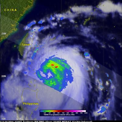
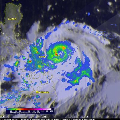
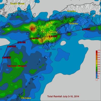
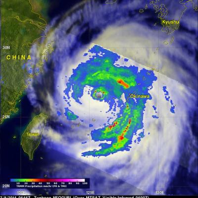
Typhoon Matmo Drenches Taiwan

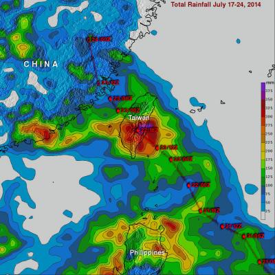
Typhoon Matmo hit eastern Taiwan at it's peak power with winds estimated at 85kts (about 98 mph). In addition to damaging winds Matmo produced very heavy rainfall while passing over central Taiwan. The TRMM-based, near-real time Multi-satellite Precipitation Analysis (TMPA) at the NASA Goddard Space Flight Center was used in this analysis to show rainfall totals for the period from July 17-24, 2014. It shows that rainfall totals greater than 400 mm (about 15.7 inches) soaked eastern Taiwan. Heavy rainfall also occurred yesterday over the Taiwan Strait. This band of heavy rainfall associated

Matmo's Menacing Taiwan

The TRMM satellite saw typhoon Matmo nearing Taiwan on July 21, 2014 at 2316 UTC. TRMM's Microwave Imager (TMI) and Precipitation Radar (PR) showed that Matmo contained a large area of precipitation falling at a rate of over 61 mm (about 2.4 inches) per hour northeast of Matmo's center. After battering Taiwan today, typhoon Matmo is predicted to make a second landfall in China tomorrow.

Super Typhoon Rammasun Strikes the Southern Coast of China

Super typhoon Rammasun struck the southern coast of China on Friday July 18th as a very powerful super typhoon with sustained winds estimated at 135 knots (~155 mph or equivalent to a Category 5 hurricane on the US Saffir-Simpson scale), making it the strongest typhoon to hit the area in several decades. Rammasun made landfall at 3:30 pm (local time) on Hainan Island where the southern half of the intense eye wall raked across the northeast tip of that island. The center then quickly cut across the Qiongzhou Strait separating Hainan from the Leizhou Peninsula to the north. The right half of
Potential Tropical Development Southeast Of Hawaii JacobAdmin Fri, 07/18/2014
Early this morning at 1100 UTC the TRMM satellite flew above an area where a possible tropical cyclone is developing southeast of the Hawaiian Islands (12 North 140 West). A rainfall analysis from TRMM's Microwave Imager (TMI) and Precipitation Radar (PR) instruments is shown on the left overlaid on a GOES-WEST image received at the exact same time. TRMM PR data found powerful storms near the center of the tropical disturbance where rain was falling at a rate of over 105 mm (about 4.1 inches). Radar reflectivity values of over 50dBZ were being returned to the satellite from intense rain

Deadly Typhoon Rammasun Crosses The Phillipines

Typhoon Rammasun known locally as "Glenda" is the most powerful typhoon to hit the Philippines this year. As of today, Ten deaths have been attributed to Rammasun. Flooding and landslides are expected due to heavy rainfall. Typhoon Rammasun's track was north of Super Typhoon Haiyan's path of destruction through the Philippines in November 2013. The image above is a preliminary analysis of rainfall during the period when typhoon Rammasun was moving over the Philippines. Typhoon Rammasun's track is shown in red. This analysis is the result of a TRMM-calibrated merged global Multi-satellite

Typhoon Rammasun Strikes The Philippines

Today typhoon Rammasun is pounding the Philippines with strong winds and heavy rainfall. Rammasun was labeled a tropical storm on July 12, 2014 when it formed west of Guam. Rammasun strengthened and was upgraded to a typhoon on July 14, 2014. Typhoon Rammasun became still more powerful and had winds estimated at 100kts (about 115 mph) today making it a category three tropical cyclone on the Saffir-Simpson hurricane wind scale. The images above show typhoon Rammasun as the TRMM satellite flew over on July 14, 2014 at 1819 UTC and again on July 15, 2014 at 0410 UTC. These images show that

Tropical Storm Neoguri Soaks Southern Japan

Once powerful typhoon Neoguri is dropping copious rainfall as it passes over southern Japan as a tropical storm. Heavy rainfall from Neoguri fell on land that was already soaked earlier this month by a slow moving seasonal frontal system. Flooding and mudslides from Neoguri have caused the deaths of three people in Japan this week. The TRMM Multi-Satellite Precipitation Analysis (TMPA), produced at Goddard Space Flight Center, combines the rainfall estimates generated by TRMM and other satellites (3B42). The analysis above shows a near-real time Multi-satellite Precipitation Analysis (TMPA)

Neoguri A Little Weaker

TRMM satellite had another good view of typhoon NEOGURI on July 8, 2014 at 0545 UTC. With wind speeds of 110 kts (about 127 mph) NEOGURI had weakened to a strong category three typhoon. A rainfall analysis from TRMM's Microwave Imager (TMI) and Precipitation Radar (PR) is shown overlaid on a MTSAT Visible/Infrared image from 0600 UTC. Rainfall was measured by TRMM PR falling at a rate of over 117 mm (about 4.6 inches) per hour in a rain band affecting Okinawa. A simulated 3-D view (from the east) shows NEOGURI's rainfall structure at the time of this TRMM satellite pass. Powerful thunderstorms

Powerful Hurricane Arthur Hits North Carolina

Hurricane Arthur battered North Carolina after coming ashore late last night at 0315 UTC (11:15 PM EDT). The TRMM satellite flew directly over Arthur on July 3, 2014 at 1922 UTC ( 3:22 PM EDT) as the hurricane was becoming increasingly more powerful. An analysis of rainfall from TRMM's Microwave Imager (TMI) and Precipitation Radar (PR) instruments was overlaid on a 1926Z GOES-EAST Visible/Infrared image. Intense bands of thunderstorms north of Arthur's well defined eye were revealed by TRMM to be dropping rainfall at a rate of over 98.4 mm ( about 3.9 inches) per hour. One of the TRMM

TRMM Sees Arthur Intensifying

Tropical storm Arthur intensified and was upgraded to a hurricane by the National Hurricane Center (NHC) early this morning. The TRMM satellite flew above the intensifying tropical storm on July 2, 2014 at 2156 UTC (7:56 PM EDT). At that time TRMM found that Arthur hadn't formed an eye but had heavy rain near the center of a well defined circulation. Rainfall derived from TRMM's Microwave Imager (TMI) and Precipitation Radar (PR) is shown overlaid on a GOES-EAST Visible/Infrared image collected at the same time as the TRMM pass.