Hal Pierce

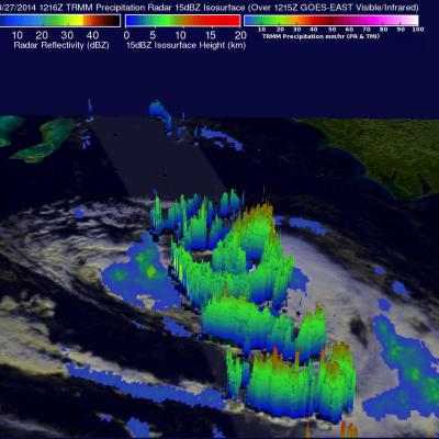
Baja California Battered And Drenched By Odile

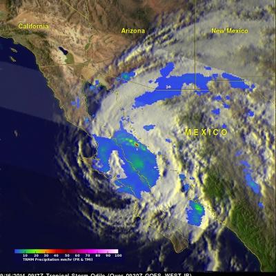
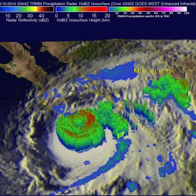
Category three hurricane Odile caused widespread destruction after hitting Baja California on Sunday night. Odile had weakened to a tropical storm with winds of about 55 kts ( 63.3 mph) when the TRMM satellite flew over on September 16, 2014 at 0917 UTC (2:19 AM PDT). Odile was still well organized and TRMM's Precipitation Radar (PR) measured rain falling at a rate of almost 130 mm (5.1 inches) per hour northeast of the tropical storms's center of circulation. The tops of some strong thunderstorms over the Gulf Of California were reaching heights of 13km (8 miles) and returning radar

Hurricane Odile Strikes Baja California

The TRMM satellite passed directly above hurricane Odile on September 15, 2014 at 0344 UTC. This was about an hour before the strong Hurricane hit Baja California near Cabo San Lucas at around 0445 UTC (September 14, 2014 9:45 PM PDT). The National Hurricane Center (NHC) hurricane discussion on September 15, 2014 said, "The estimated intensity of 110 kt at landfall ties Odile with Olivia (1967) as the strongest hurricane to make landfall in the satellite era in the state of Baja California Sur". The image above shows rainfall derived from TRMM's Precipitation Radar (PR) and Microwave Imager

Tropical Storm Edouard forms in the Atlantic

The formation of Tropical Storm Edouard in the central Atlantic marks the climatological peak of the Atlantic hurricane season in what has so far been a rather average season in terms of the number of storms. Edouard became the fifth named storm of the season after forming overnight in the central Atlantic about 1645 km (~1020 miles) west of the Cape Verde Islands. In a typical season there are about 10 named storms and 6 hurricanes. So far this year, halfway through the season, there have been 5 named storms and 3 hurricanes, but none have posed a major threat to the US, and there have been

Tropical Storm Odile Forms

The hurricane season continues to be active in the eastern Pacific Ocean. Hurricane Norbert dissipated a few days ago and then tropical storm Odile formed yesterday (September 10, 2014) in the same area where Norbert formed. The TRMM satellite flew over tropical storm Odile on September 11, 2014 at 0418 UTC and collected data used in the images above. The first image shows a rainfall analysis made from TRMM's Microwave Imager (TMI) and Precipitation Radar (PR) data overlaid on a 0430 UTC GOES-WEST enhanced infrared image. TRMM PR found that Odile was dropping rain at the extreme rate of over

Moisture From Norbert Spreads Heavy Rain Over Southwest

The TRMM satellite flew above the post-tropical cyclone remnants of former hurricane Norbert on September 8, 2014 at 0849 UTC (1:49 AM PDT). This image shows TRMM rainfall derived from the Microwave Imager (TMI) and Precipitation Radar (PR) instruments overlaid on a 0900 UTC GOES-EAST enhanced Infrared image. These data show that only a small amount of light to moderate rainfall was located around Norbert's center of circulation. This view shows that heavy rainfall was being produced over the southwestern United States. This 3-D image was made from TRMM Precipitation Radar (PR) data. It shows

Norbert & Dolly Rain On Both Mexican Coasts

Tropical storm Dolly dissipated quickly after coming ashore yesterday in eastern Mexico but dropped heavy rain in some areas near the Gulf coast. At the same time tropical storm Norbert was approaching from the west and contributing to rainfall near Mexico's Pacific coast. TRMM-based, near-real time Multi-satellite Precipitation Analysis (MPA) data for the period from August 28 to September 4, 2014 were used in the analysis shown above. The approximate past locations of the tropical cyclones at 0000Z and 1200Z are shown overlaid in red on this analysis. The heaviest rainfall totals were found

Tropical Storm Dolly Hits Eastern Mexico

Tropical storm Dolly is dissipating after coming ashore in eastern Mexico late yesterday evening. The TRMM satellite flew over tropical storm Dolly early on September 3, 2014 at 0844 UTC ( 3:33 AM CTD) providing data used in the image above. TRMM's Microwave Imager (TMI) collected with that orbit showed that Dolly was dropping light to moderate rainfall near the dissipating storm's center of circulation. Moderate to heavy rainfall, falling at a rate of over 30 mm ( about 1.2 inches) per hour, was shown in a strong band of showers moving ashore north of Dolly's center. The TRMM satellite had a

Cristobal Passes Northwest Of Bermuda

The TRMM satellite had a very good view of Cristobal on August 28, 2014 at 1258 UTC (8:58 EDT) as the hurricane passed well to the northwest of Bermuda. Rainfall derived from TRMM's Microwave Imager (TMI) and Precipitation Radar (PR) data is shown overlaid on a 1300 UTC GOES-EAST Visible/Infrared image. TRMM PR found some intense thunderstorms producing rain at a rate of almost 78 mm (about 3.1 inches) per hour in a band of precipitation feeding into Cristobal's southeastern side. The next image is a simulated 3-D view (from the west) of Cristobal's rainfall structure using radar reflectivity

Hurricane Cristobal Poised to Head Out to Sea

Cristobal, still a minimal Category 1 hurricane on the US Saffir-Simpson scale, has been slowly making its way northward up from the southeastern Bahamas on a track generally parallel to the eastern seaboard. The storm now appears poised to recurve away from the US East Coast and head for the central Atlantic as it begins to feel the effects of an approaching shortwave trough embedded in the westerlies that's moving eastward out of the Great Lakes region. TRMM made an overpass of Cristobal this morning, which is shown in this image taken at 12:16 UTC (8:16 am EST) 27 August 2014. At the time

Cristobal Becomes A Hurricane

Tropical storm Cristobal was upgraded to a hurricane yesterday evening at 8:20 PM (August 26, 2014 at 0020 UTC). The TRMM satellite flew above the newly designated hurricane this morning at 1135 UTC (7:35 AM EDT) providing rainfall data used in this image. A rainfall analysis derived from TRMM's Microwave Imager (TMI) and Precipitation Radar (PR) data is shown overlaid on a 1126 UTC GOES-EAST Visible/Infrared image. Cristobal was a category one hurricane with sustained winds estimated to be slightly above 65 kts (about 75 mph) with this view. Cristobal's didn't have a clearly defined eye with