

Harvey Hits Texas, Unleashes Major Flooding
Despite its earlier demise, after rejuvinating over the warm waters of the Gulf of Mexico, Hurricane Harvey has become a major weather maker as it unleashes historical flooding over parts of coastal Texas. Harvey began on the 17th of August as a weak tropical storm about 250 miles (~400 km) east of Barbados in the Leeward Islands. Over the next two days, Harvey continued moving steadily westward passing through the Leeward Islands as a still weak tropical storm and entered into the east central Caribbean. On the 19th, Harvey succumbed to the effects of northeasterly wind shear over the central Caribbean and lost its cyclonic circulation and weakened back into a tropical wave. The remnants of what was once Harvey then passed over the Yucutan Peninsula and into the Bay of Campeche. Typically, it is hard for a system to reform after dissipating as well as after passing over land. However, the environmental conditions were favorable for development and the water temperatures in the Gulf of Mexico very warm. This allowed Harvey first to reform into a tropical depression on the morning of the 23rd of August then strengthen back to a tropical storm later that evening. Having recovered its structure, Harvey was then able take further advantage of the low wind shear and warm waters and continue to intensify, becoming a hurricane by midday on the 24th and then rapidly intensifying overnight into a Category 2 storm with maximum sustained winds reported at 110 mph (~175 kph) by the National Hurricane Center (NHC) at 15:00 UTC (10:00 am CDT) the next morning. Now moving northwest across the western Gulf and Mexico and headed straight for the central Texas coast, Harvey continued to get stronger during the day on the 25th and reached its peak intensity as a Category 4 storm with sustained winds of 130 mph (215 kph) at 6:00 pm CDT according to NHC. Harvey maintained this intensity until it made landfall later that evening at around 10:00 pm CDT as a Category 4 hurricane near Rockport, Texas, about 30 miles east-northeast of Corpus Christi. After making landfall, Harvey weakened and its winds decreased back down to tropical storm intensity by 1:00 pm CDT the next day on the 26th; however, as had been forecast, the steering currents collapsed, bringing the storm to a near stand still just inland from the Texas Gulf Coast and setting the stage for a catostrophic flooding event.
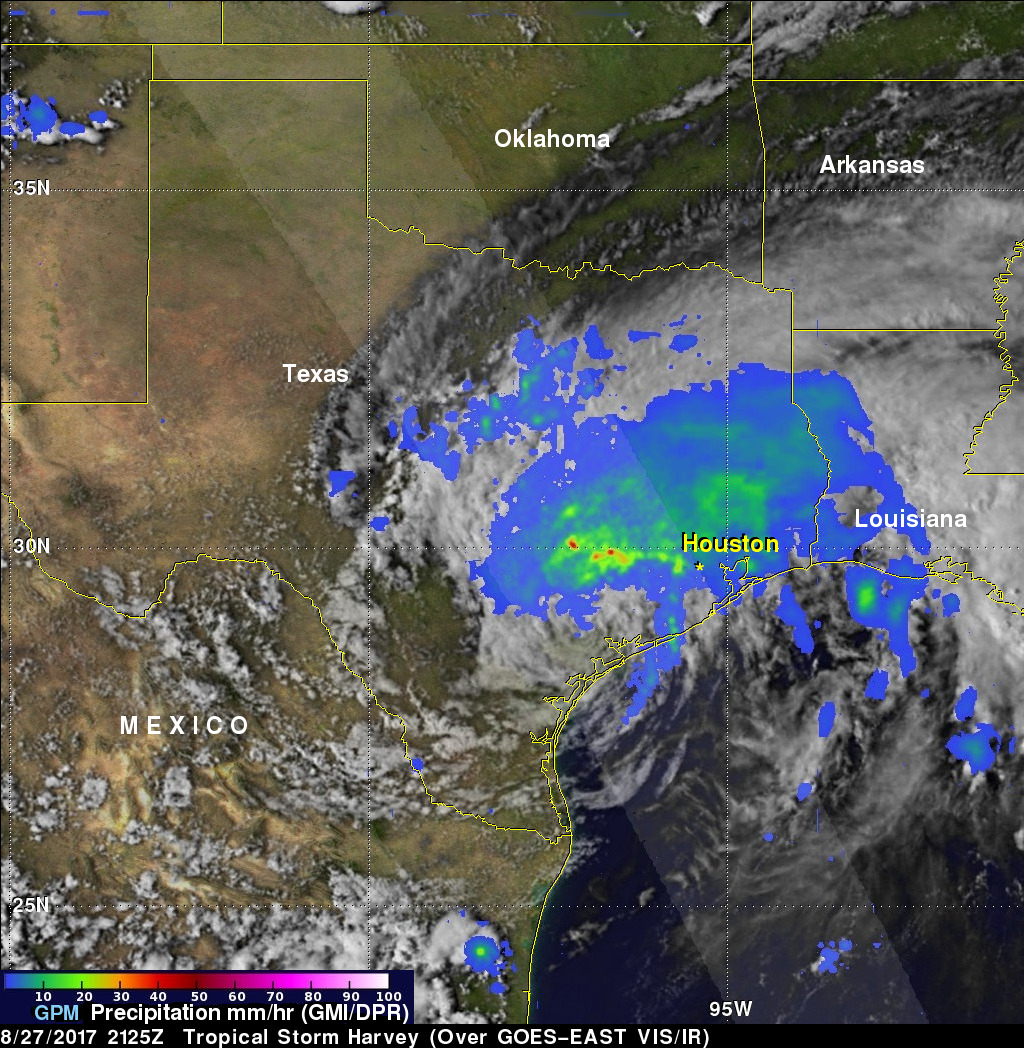
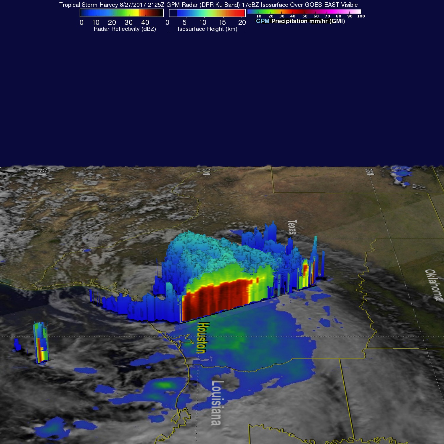
GPM captured this image of Harvey at 21:25 UTC (4:25 pm CDT) on the 27th of August nearly two days after the storm made landfall as it was meandering slowly southeast at just 2 mph (~4 kph) near Victoria, Texas west of Houston. The image shows rain rates derived from GPM's GMI microwave imager (outer swath) and dual-frequency precipitation radar or DPR (inner swath) overlaid on enhanced VIS/IR data from the GOES-East satellite. Harvey's cyclonic circulation is still quite evident in the VIS/IR clouds, but GPM shows that the rainfall pattern is highly asymmetric with the bulk of the rain located north and east of the center. A broad area of moderate rain (green areas) can be seen stretching from near Galveston Bay to north of Houston and back well to the west. Within this are embedded areas of heavy rain (red areas); the peak estimated rain rate from GPM at the time of this overpass was 96 mm/hr (~3.77 inches per hour). With Harvey's circulation still reaching out over the Gulf, the storm is able to draw in a continous supply of warm moist air to sustain the large amount of rain it is producing.

NASA's Integrated Multi-satellitE Retrievals for GPM or IMERG product is used to make estimates of precipitation from a combination of space-borne passive microwave sensors, including the GMI microwave sensor onboard the GPM core satellite, and geostationary IR (infrared) data. This image of IMERG rainfall estimates for the period 21 to 28 August 2017 shows the accumulated effects of all of the rain from Harvey to date. So far, IMERG shows rainfall totals have reached on the order of 20 inches (purple shading) from the coast near Galveston Bay to in and around the Houston area as a result of the near continuous stream of showers and rain being drawn over the coast in rainbands on the eastern side of Harvey's counter clockwise cyclonic circulation. Elsewhere, at least 10 inches (red shading) are shown to have fallen from western Louisiana all the way to near Corpus Christi on the coast. The result has been widespread, massive flooding across the region and brings back memories of Tropical Storm Allison, which dropped up to 40 inches of rain in Texas back in 2001 and caused devasting flooding in the Houston area. So far, Harvey is being blamed for at least 5 deaths, but the end is still to come. Due to its continued slow movement and proximity to the warm Gulf water, NHC is forecasting Harvey to bring 15 to as much as 25 more inches of rain to the upper Texas coast over the next few days, including the Houston area.
Images produced by Hal Pierce (SSAI/NASA GSFC) and story by Stephen Lang (SSAI/NASA GSFC).