GPM Applications Banner: Disasters

Using GPM Data for Disasters and Risk Management

Too much or too little rainfall can have significant impacts on populations around the world. As population and global temperatures increase, it is crucial to understand what locations will become more vulnerable to extreme rainfall and drought and the subsequent natural hazards (e.g., landslides) and risks (e.g., lose of property) they impose. Satellites allow us to monitor changes in the precipitation, especially over oceans and regions where ground-based data are sparse. With its near-real-time precipitation estimates and near global coverage, GPM serves as an essential tool for assessing risk and planning disaster response and recovery.  For example, near-real-time precipitation data from GPM are used within various models to help monitor and predict the path and intensity of tropical storms, vegetation fire starting and spreading, and landslide activity across the globe. The Disasters and Risk Management applications area seeks to use the GPM precipitation satellite data to improve forecasting, preparation, response, recovery, mitigation and insurance of natural hazards including tropical cyclones, floods, droughts, wildfires, landslides, and other extreme weather events.

Overview

Sections

GPM Data for Decision Making

Image

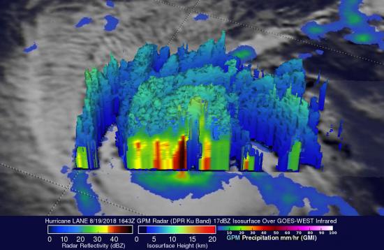
GPM's GMI / DPR provides views of hurricane Lane’s precipitation, showing intense storms near the center on August 19, 2018. Credit: Hal Pierce (SSAI/NASA GSFC).


The GPM Mission provides insight into how and why some tropical cyclones intensify and others weaken as they move from tropical to mid-latitude systems. The GPM Core Observatory’s GMI and DPR instruments allow scientists to study the internal structure of storms throughout their life cycle, and view how they change over time. Specifically, the GMI has the capability to measure the amount, size, intensity, and type of precipitation, from heavy-to moderate rain to light rain and snowfall. The DPR returns three-dimensional profiles and intensities of liquid and solid precipitation, revealing the internal structure of storms within and below clouds. Scientists use these instruments to track tropical cyclones and forecast their progression and to verify their tropical cyclone computer models. They also use instrument data to understand the distribution and movement of latent heat throughout the storm, particularly in the development of hot towers in the wall of clouds around the eye, which have been linked to rapid intensification. Together, these instruments will improve hurricane tracking and forecasts, which can help decision makers save lives.

View tropical cyclones articles

Image

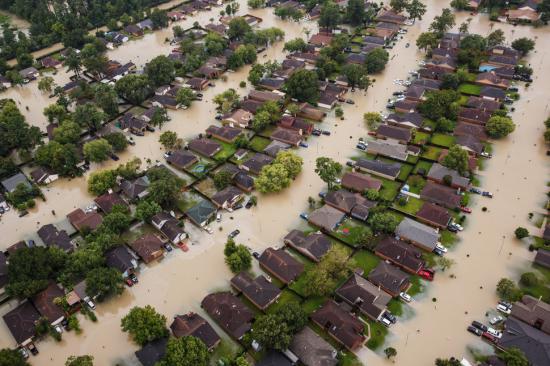
Submerged Houston neighborhoods in the wake of Tropical Storm Harvey on August 29, 2017. Credit: Marcus Yam / Getty Images

To better understand and predict floods scientists have developed hydrological models based on how much rainfall occurs and where the water will likely go once it hits the ground. They use several satellite precipitation datasets within these models to provide near real-time estimates of when and where areas may flood on local, regional, and global scales. GPM provides frequent precipitation observations with near global coverage, of which 80% are less than 3 hours apart, exceeding the minimum deemed necessary for hydrometeorological applications. Therefore, rainfall data measured by the GPM Mission and its products, like the Integrated Multi-satellitE Retrievals for GPM (IMERG) data product, helps us better understand how changing precipitation patterns at multiple scales translates changes into hydrologic fluxes and states that can be used for flood detection and warning systems.

View floods articles

Image

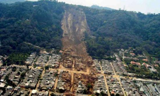
Aerial view of landslide that buried Colonia las Colinas, El Salvador. Credit: USGS

Landslides are one of the most pervasive hazards in the world, resulting in more fatalities and economic damage than is generally recognized. Saturating the soil on vulnerable slopes, intense and prolonged rainfall is the most frequent landslide trigger, but seismicity, river undercutting, freeze-thaw processes, and human activity can also cause extensive and devastating landslides. Understanding where and when landslides have occurred in the past and where they may occur in the future is extremely challenging because of the lack of ground-based sensors at the landslide site to provide both triggering information (e.g. rainfall intensity and duration), and the timing and extent of the mass movement events. Precipitation measurements from remote sensing allows us to gain new insight to identify landslide activity, characterize the triggering patterns of these events spatially and temporally, assess the surface conditions for potential activity, and support the full cycle of disaster risk assessment. In particular, GPM’s more frequent and more detailed coverage of precipitation across the globe can help improve landslide model accuracy and expand potential landslide forecasting capabilities.

Learn more about GPM applications for landslides

Image

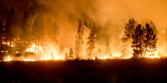
High severity fire in the western U.S. Credit: USDA Forest Service

Wildfires play an integral role in maintaining ecosystem biodiversity and structure.  Wildfires, which include any non-structure fire that occurs in vegetation or natural fuels, is an essential process that connects terrestrial systems to the atmosphere and climate.  However, the effects of fire can be disastrous, both immediately (e.g., poor air quality, loss of life and property) and through post-fire impacts (floods, debris flows/landslides, poor water quality). Wildfires can be triggered by several factors including lightning, high winds, drought, and people. 

There are several ongoing activities using remote sensing data to support pre-, active- and post-fire research, as well as the applicable use of these data and products in support of management decisions and strategies, policy planning and in setting rules and regulations. Frequent precipitation measurements from GPM along with temperature and land cover measurements from other satellites can provide key information to determine the overall dryness of an area and the potential start and spread of a vegetation fire. 

View wildfires articles
 

Image

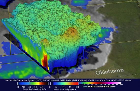
GPM's GMI and DPR observe rainfall accumulation over the storm and 3-D vertical structure in a line of intense storms associated with the mesoscale convection system over northern New Mexico and Oklahoma on June 25, 2018. Credit: Hal Pierce (SSAI/NASA GSFC)


Many regions in the world experience severe weather such as thunderstorms, hail, tornadoes, and blizzards every year. Severe weather usually comes with heavy precipitation and causes unexpected hydrometeorological hazards, such as floods or landslides, which can affect thousands of people, posing a threat on life and property. Therefore, it is critically important to monitor severe weather and estimate heavy precipitation so that the occurrence and intensity of associated hydrometeorological hazards can be well identified, detected, and forecasted. Where ground-based instruments are sparse, remote sensing systems can be especially useful to observe and monitor these extreme events. Microwave sensors used by the GPM Mission allows scientists to map thunderstorm cores to gain insight into storm structures and mesoscale dynamics (e.g. thunderstorms to hurricanes) as well as detect light rain to moderate-to heavy rain and snowfall. Delivery of precipitation data from the GPM Mission is crucial for operational and research organizations to advance precipitation measurement science to improve weather forecasting that can subsequently benefit society for years to come. 

View severe weather articles


Image

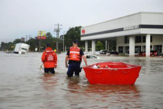
Coast Guardsmen use a boat to assist residents during severe flooding around Baton Rouge, LA on August 14, 2016. Credit: Petty Officer 3rd Class Brandon Giles/Coast Guard

Every year, landslides wipe out roads or town, devastating floods put city blocks underwater, or a violent hurricane devastates the coastal communities. Natural hazards, like Hurricane Maria or flooding in Houston, have huge impacts on people around the world. Heavy rains and large storm systems are often significant factors that cause these disasters to have huge economic costs or even kill people. The best defense against natural hazards is accurate and early warning systems. Understanding the timing, location, and intensity of precipitation extremes using GPM data, organizations that handle disaster response and recovery can monitor, assess, and understand the damage or potential damage of a disaster. These efforts help to minimize the impact of a natural disaster as well as effectively coordinate with organizations and the public before, during, after so as many people are safe and needs are met. 

Image

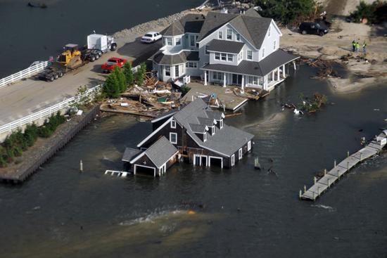
A house on the Jersey Shore submerged in water in the aftermath of Hurricane Sandy.  Credit: Jim Greenhill via BU Today

The insurance and disaster management industries are closely related; dealing with the risk of natural disaster and managing the events following disasters. Reinsurance companies work to understand the need of its potential customers and the risks to which they may be exposed.  A companies’ success is generally tied to the ability to forecast the probability of natural hazards, including storms, floods, and landslides. Earth Science data and information derived from remote sensing instruments over the last decade have made it more feasible to develop climate records and understand region’s susceptibility to a natural disaster. Such data are then used to design payout triggers when natural hazards occurs. Policyholders are then compensated according to the strength of the measured event against those triggers. Specially, reinsurance companies across the world use rainfall data from GPM to develop rainfall thresholds to design insurance payouts when disasters strike. 

Disasters Featured Resources

Jump to a Year

2022 | 2021 | 2020 | 2019 | 2018

2017 | 2016 | 2015 | 2014 | 2013

2012 | 2011 | 2010 | 2009 | 2008

2007 | 2006 | 2005 | 2004 | 2003

2002

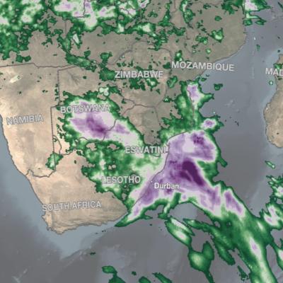
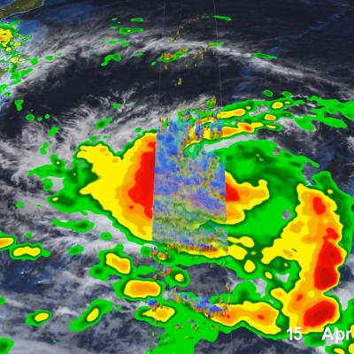
IMERG rainfall totals in South Africa, April 5 - 18, 2022.
An upper-level area of low pressure tapped into the warm waters of the South Indian Ocean to bring heavy rains and flooding to parts of South Africa during the second week of April. The event unfolded when an upper-level trough of low pressure embedded within the midlatitude westerlies traversed the southern part of Africa from west to east. As the trough approached the east coast of South Africa, an area of low pressure became detached from the main flow, this “cut off” low then drifted over the warm waters of the Agulhas Current, which channels warmer waters from the tropical Indian Ocean
GPM Overpass of Typhoon Surigae
Although it was only the 2nd named storm of the 2021 Pacific typhoon season, Typhoon Surigae became not only the first super typhoon of the season, but also the strongest tropical cyclone of 2021 worldwide. The majority of storms in the Northwest Pacific region form between June and Nov., but the season runs yearlong, as storms can form in any month in this region, which stretches from 100 degrees East to 180 degrees East, north of the equator. Surigae originated from an area of low pressure about 700 miles south of Guam. Persistent thunderstorm activity resulted in the formation of a tropical
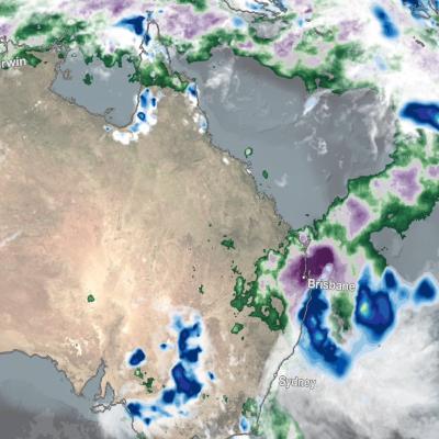
IMERG Rainfall Totals from Australian :"Rain Bomb" in March 2022
The below animation shows surface rainfall estimates from NASA’s IMERG multi-satellite precipitation product for the week starting on Feb. 22, 2022 at 0000 UTC and ending on Feb. 28, 2022 at 2330 UTC. Areas shaded in blue and yellow show three-hour average snapshots of IMERG rain rates every half-hour overlaid on cloudiness (shown in white/gray) based on geosynchronous satellite infrared observations. Below the rain rates and cloudiness data, IMERG rainfall accumulations are shown in green and purple. Tropical Cyclone Anika’s track is shown with a gray line based on data from the U.S. Navy-Air
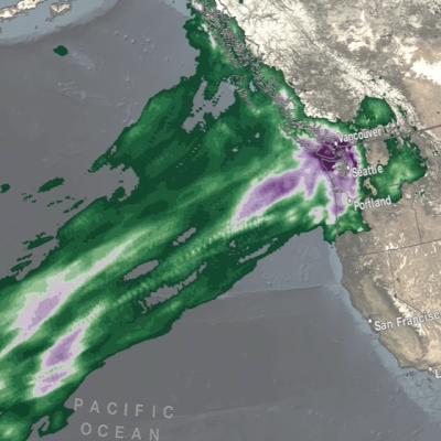
IMERG rainfall totals from the Nov. 2021 atmospheric river.
The Pacific Northwest coast saw two atmospheric rivers (ARs) bring heavy rains from Nov. 10-16, 2021, resulting in severe flooding, landslides, and damage to infrastructure in the British Columbia province of Canada. ARs are long, narrow corridors of water vapor that travel vast distances above the ocean from warm, tropical regions to higher latitudes, where they often release their moisture as rainfall when they reach land areas. While ARs occur across the globe, this year has been notable for several strong events that have impacted the Pacific Northwest coast. The two atmospheric rivers in
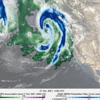
IMERG rainfall totals from recent atmospheric river.
The Pacific Northwest experienced a memorable series of storms in late Oct. 2021 as several low-pressure systems rolled in from the northeast Pacific Ocean. One of the systems was classified by meteorologists as a “bomb cyclone”, meaning that its central pressure (an indication of storm strength) had dropped particularly rapidly in a short time period. At its minimum pressure (highest strength), the system was reported by the National Weather Service to have had the lowest pressure of a system over the northeastern Pacific Ocean since reliable observations began in 1974. The system was notable
IMERG rainfall totals in South Africa, April 5 - 18, 2022.
An upper-level area of low pressure tapped into the warm waters of the South Indian Ocean to bring heavy rains and flooding to parts of South Africa during the second week of April. The event unfolded when an upper-level trough of low pressure embedded within the midlatitude westerlies traversed the southern part of Africa from west to east. As the trough approached the east coast of South Africa, an area of low pressure became detached from the main flow, this “cut off” low then drifted over the warm waters of the Agulhas Current, which channels warmer waters from the tropical Indian Ocean
IMERG rainfall totals from the Nov. 2021 atmospheric river.
The Pacific Northwest coast saw two atmospheric rivers (ARs) bring heavy rains from Nov. 10-16, 2021, resulting in severe flooding, landslides, and damage to infrastructure in the British Columbia province of Canada. ARs are long, narrow corridors of water vapor that travel vast distances above the ocean from warm, tropical regions to higher latitudes, where they often release their moisture as rainfall when they reach land areas. While ARs occur across the globe, this year has been notable for several strong events that have impacted the Pacific Northwest coast. The two atmospheric rivers in
IMERG Rainfall Rates and MUR Sea Surface Temperatures from the 2020 Hurricane Season
Forecasters predicted an above-normal hurricane season for 2020. They weren’t wrong. As the 2020 Atlantic hurricane season smashed records with an unprecedented 30 named storms , NASA’s Earth Applied Sciences Disasters Program stood up to the challenge. The Disasters Program helps leaders and responders at national, regional, and local levels leverage NASA’s technology and expertise to assess, predict, and understand disasters' impacts. The Disasters Program targets a wide range of hazards and disasters , and while NASA is not an operational response agency, the agency offers access to unique
IMERG Total from Cyclone Gati
On November 22, 2020, Cyclone Gati became the strongest storm to hit Somalia since satellite records began five decades ago. Gati made landfall with maximum sustained winds of 170 kilometers (105 miles) per hour, a category 2 storm on the Saffir-Simpson scale . The storm brought more than a year’s worth of rain to the region in two days. Local authorities report at least eight people were killed and thousands have been displaced. The map above shows rainfall accumulation from November 21-23, 2020. These data are remotely-sensed estimates that come from the Integrated Multi-Satellite Retrievals
Landslide Risk in Central America
On November 3, 2020, Hurricane Eta made landfall as one of the most powerful hurricanes to hit Central America in years. The category 4 storm destroyed hundreds of homes, killed more than 100 people, and brought torrential rains that triggered large and numerous landslides in Guatemala and Honduras. Less than two weeks later, Hurricane Iota —an even more powerful category 4 storm—nearly retraced Eta’s path. Within hours of Eta’s landfall and flooding rains , researchers at NASA’s Goddard Space Flight Center worked to predict landslides and map the storm’s aftermath. One team assessed potential
Hurricane Eta over Florida
After striking the northeast coast of Nicaragua as a powerful Category 4 storm back on November 3, Hurricane Eta weakened rapidly over Central America but still brought major flooding and triggered numerous landslides that so far have resulted in at least 250 fatalities across the region, according to media reports. Eta was down to a tropical depression when the center re-emerged over the northwestern Caribbean on the evening of November 5. An upper-level trough over the Gulf of Mexico first steered Eta northeastward towards Cuba on the 6th. Because it was disorganized after its trek across
Hurricane Eta IMERG Screenshot
The extremely active 2020 Atlantic hurricane season, aided by the ongoing La Niña, continues on. After Hurricane Zeta made landfall along the northern part of the Gulf Coast, yet another hurricane has arisen - Hurricane Eta, the strongest of the season. Like Zeta, Eta also formed in the Caribbean, where sea surface temperatures are still running quite warm at around 29° C, almost a full degree above average and well above the typical 26° C needed for tropical cyclone development. But while Zeta turned north into the Gulf of Mexico, Eta moved westward where it delivered powerful winds and
GPM Overpass of Hurricane Zeta on 10/28/20
As Hurricane Zeta moves towards landfall on the U.S. Gulf Coast, NASA has eyes on the storm with an array of Earth-observing instruments and stands ready to aid affected communities with critical data and analysis. Zeta is following a path similar to Hurricane Delta, which after crossing the Yucatan Peninsula made its way across the Gulf of Mexico and struck the Louisiana coast as a Category 2 hurricane on October 9. If Zeta makes landfall as expected along the northern Gulf Coast, it will become the 7th named storm to do so in this record-breaking season, following Tropical Storm Cristobal
Hurricane Forecasting Screenshot
The powerful hurricane that struck Galveston, Texas on September 8, 1900, killing an estimated 8,000 people and destroying more than 3,600 buildings, took the coastal city by surprise. This video looks at advances in hurricane forecasting in the 120 years since, with a focus on the contributions from weather satellites. This satellite technology has allowed us to track hurricanes – their location, movement and intensity. “One of the dramatic impacts is that satellite data keeps an eye on the target," especially over unpopulated areas such as oceans, said JPSS Director Greg Mandt. “We’re sort...
Farmers looking at an App
Unexpected shocks from natural hazards can affect populations throughout the globe, threatening sustainable development and resilience. However, the impacts of these events, such as extreme precipitation or drought, disproportionately affect the developing world where individuals often are not insured and live and work in conditions that leave them vulnerable to natural disasters. This can lead to significant economic and environmental challenges if preventive measures or mitigating measures are not taken in time. To reduce risks from natural disasters and build climate resilience, decision...
Landslide Risk in High Mountain Asia
More frequent and intense rainfall events due to climate change could cause more landslides in the High Mountain Asia region of China, Tibet and Nepal, according to the first quantitative study of the link between precipitation and landslides in the region. The model shows landslide risk for High Mountain Asia increasing in the summer months in the years 2061-2100, thanks to increasingly frequent and intense rainfall events. Summer monsoon rains can destabilize steep mountainsides, triggering landslides. Credits: NASA's Earth Observatory/Joshua Stevens High Mountain Asia stores more fresh...
Rain Brought Brief Relief to Australia
For much of the 2019-2020 austral summer, plumes of bushfire smoke have billowed from southeastern Australia in such large amounts that the ground was barely visible in satellite images. In mid-January, some of those plumes were finally quelled by a few days of much-needed rainfall.
GPM Data Mitigates Landslide Risks in Bangladesh
Camp managers and other local officials overseeing Rohingya refugee camps in Bangladesh are now incorporating NASA satellite observations into their decision making in order to reduce the risk to refugees from landslides and other natural hazards. Information like daily rain totals can help inform how to lay out refugee camps and store supplies. More than 740,000 Rohingya refugees have fled to Bangladesh since August 2017. Many of them have sought shelter in camps located in the hilly countryside, where landslide risk may be the greatest. Increasing this danger is Bangladesh’s intense monsoon season. Approximately 80 percent of Bangladesh's yearly rain falls in just five months, from June to October, bringing with it an increased risk of flash flooding and landslides.
Rain Patterns During the Alaska Wildfires
NASA's satellite-based estimate of global precipitation can provide valuable information to officials monitoring the many wildfires in Alaska this summer. Wildfires occur in Alaska each summer, but July 2019 is shaping up to be a particularly active month. Few rain gauges exist in the large tracts of Alaskan wilderness, but wildfires unchecked can spread to populated areas within the state. Satellite-based precipitation estimates are particularly valuable here because of precipitation's relationship to wildfire hazard. The movie shows NASA's IMERG precipitation estimates for May 1 through July...
NASA Rainfall Data and Global Fire Weather
The Global Fire WEather Database (GFWED) integrates different weather factors influencing the likelihood of a vegetation fire starting and spreading. It is based on the Fire Weather Index (FWI) System, which tracks the dryness of three general fuel classes, and the potential behavior of a fire if it were to start. Each day, FWI values are calculated from global weather data, including satellite rainfall data from the Global Precipitation Measurement (GPM) mission.
Help NASA Create the Largest Landslide Database
Landslides cause thousands of deaths and billions of dollars in property damage each year. Surprisingly, very few centralized global landslide databases exist, especially those that are publicly available. Now NASA scientists are working to fill the gap—and they want your help collecting information.
Modeling Landslide Threats in Near Realtime
For the first time, scientists can look at landslide threats anywhere around the world in near real-time, thanks to satellite data and a new model developed by NASA. The model, developed at NASA's Goddard Space Flight Center in Greenbelt, Maryland, estimates potential landslide activity triggered by rainfall. Rainfall is the most widespread trigger of landslides around the world. If conditions beneath Earth's surface are already unstable, heavy rains act as the last straw that causes mud, rocks or debris — or all combined — to move rapidly down mountains and hillsides. A new model has been...
GPM Catches Hurricane Nate's Landfall
NASA's GPM satellite helped track Nate's progress through the Gulf of Mexico and also captured Nate's landfall on the north central Gulf Coast. This animation shows instantaneous rainrate estimates from NASA's Integrated Multi-satellitE Retrievals for GPM or IMERG product over North America and the surrounding waters beginning on Thursday October 5th when Nate first became a tropical storm near the northeast coast of Nicaragua in the western Caribbean until its eventual landfall on the northern Gulf Coast on Sunday October 8th.
Intense Hurricanes Seen From Space
In 2017, we have seen four Atlantic storms rapidly intensify with three of those storms - Hurricane Harvey, Irma and Maria - making landfall. When hurricanes intensify a large amount in a short period, scientists call this process rapid intensification. This is the hardest aspect of a storm to forecast and it can be most critical to people's lives. While any hurricane can threaten lives and cause damage with storm surges, floods, and extreme winds, a rapidly intensifying hurricane can greatly increase these risks while giving populations limited time to prepare and evacuate.
GPM Sees Hurricanes Maria and Jose
GPM passed over both Hurricane Maria and Hurricane Jose on September 18th, 2017. As the camera moves in on the Maria, DPR's volumetric view of the storm is revealed. A slicing plane moves across the volume to display precipitation rates throughout the storm. Shades of green to red represent liquid precipitation extending down to the ground. The Global Precipitation Measurement (GPM) mission shows the rainfall distribution for two major storms churning in the Atlantic and Caribbean basins. The visualization shows Hurricane Jose as it continues to slowly move northward off the US East Coast east...
GPM Examines Hurricane Irma
The GPM core observatory satellite had an exceptional view of hurricane Irma's eye when it flew above it on September 5, 2017 at 12:52 PM AST (1652 UTC). This visualization shows a rainfall analysis that was derived from GPM's Microwave Imager (GMI) and Dual-Frequency Precipitation Radar (DPR) data. Irma was approaching the Leeward Islands with maximum sustained winds of about 178 mph (155 kts). This made Irma a dangerous category five hurricane on the Saffir-Simpson hurricane wind scale. Intense rainfall is shown within Irma's nearly circular eye. This 3-D cross-section through Irma's eye was...
Hurricane Irma's Heat Engine Exposed
At 1 PM EDT (1700 UTC) on September 5, 2017, the radar on the Global Precipitation Measuring Mission (GPM) satellite captured this 3D view of the heat engine inside of category-5 Hurricane Irma. Under the central ring of clouds that circles the eye, water that had evaporated from the ocean surface condenses, releases heat, and powers the circling winds of the hurricane. The radar on the GPM satellite is able to estimate how much water is falling as precipitation inside of the hurricane, which serves as a guide to how much energy is being released inside the hurricane's central "heat engine."...
GPM Captures Hurricane Harvey's Rainfall
Music: "Whirlpool," Michael Jan Levine, Killer Tracks The Global Precipitation Measurement (GPM) Core Observatory captured these images of Hurricane Harvey at 11:45 UTC and 21:25 UTC on the 27th of August nearly two days after the storm made landfall as it was meandering slowly southeast at just 2 mph (~4 kph) near Victoria, Texas west of Houston. The image shows rain rates derived from GPM's GMI microwave imager (outer swath) and dual-frequency precipitation radar or DPR (inner swath) overlaid on enhanced visible/infrared data from the GOES-East satellite. Harvey's cyclonic circulation is...
Harvey Hits Texas, Unleashes Major Flooding
Despite its earlier demise, after rejuvinating over the warm waters of the Gulf of Mexico, Hurricane Harvey has become a major weather maker as it unleashes historical flooding over parts of coastal Texas. Harvey began on the 17th of August as a weak tropical storm about 250 miles (~400 km) east of Barbados in the Leeward Islands. Over the next two days, Harvey continued moving steadily westward passing through the Leeward Islands as a still weak tropical storm and entered into the east central Caribbean. On the 19th, Harvey succumbed to the effects of northeasterly wind shear over the central...
A New Multi-dimensional View of a Hurricane
Download in high resolution from the NASA Goddard Scientific Visualization Studio NASA researchers now can use a combination of satellite observations to re-create multi-dimensional pictures of hurricanes and other major storms in order to study complex atmospheric interactions. In this video, they applied those techniques to Hurricane Matthew. When it occurred in the fall of 2016, Matthew was the first Category 5 Atlantic hurricane in almost ten years. Its torrential rains and winds caused significant damage and loss of life as it coursed through the Caribbean and up along the southern U.S...
Another Pineapple Express Brings More Rain, Flooding to California
The West Coast is once again feeling the effects of the "Pineapple Express". Back in early January one of these "atmospheric river" events, which taps into tropical moisture from as far away as the Hawaiian Islands, brought heavy rains from Washington and Oregon all the way down to southern California. This second time around, many of those same areas were hit again. The current rains are a result of 3 separate surges of moisture impacting the the West Coast. The first such surge in this current event began impacting the Pacific coastal regions of Washington, Oregon, and northern California on...
GPM Provides a Closer Look at the Louisiana Floods
Twice on August 12, 2016 GPM flew over a massive rainstorm that flooded large portions of Louisiana. The flooding was some of the worst ever in the state, resulting in a state of emergency. Tens of thousands of people were evacuated from their homes in the wake of this unprecedented event. Throughout the course of August 12 (UTC) GPM captured the internal structure of the storm twice and GPM IMERG measured the rainfall accumulation on the ground. NASA's GPM satellite is designed to measure rainfall using both passive microwave (GMI) and radar (DPR) instruments. DPR can observe 3D structures of...
http://earthobservatory.nasa.gov/IOTD/view.php?id=88319
As farmers in Nepal prepare for the benefits of monsoon season, Dalia Kirschbaum anticipates the dangers of those torrential rains—mainly, the loosening of earth on steep slopes that can lead to landslides. In this mountainous country, 60 to 80 percent of the annual precipitation falls during the monsoon (roughly June to August). That’s when roughly 90 percent of Nepal’s landslide fatalities also occur, according to a 2015 report from the United Nations Office for the Coordination of Humanitarian Affairs. “We know a high number of landslides occur around this time, so documenting them is...
Rainfall Floods the Mississippi River
A series of winter storms brought more than 20 inches of rainfall to the Midwest and southeastern United States in December 2015. Massive flooding followed throughout both the regions. An animation of rainfall data from those storms was created at NASA's Goddard Space Flight Center in Greenbelt, Maryland. This animation shows the accumulation of rainfall over the United Stated during December 2015, from the IMERG precipitation dataset. The black outline indicates the Mississippi-Missouri River basin. This version has been edited to only show the periods of significant rainfall during the month...
NASA Aids Response to Carolina Flooding
It was rain that wouldn't quit. A weather system fueled by warm moisture streaming in from the Atlantic Ocean on Oct. 3 and 4 relentlessly dumped between one and two feet of rain across most of South Carolina. The result was rivers topping their banks and dams bursting. Catastrophic flooding followed across most of the state, which has left residents in some areas without power or clean drinking water. Tracking and predicting the deluge, both as rain and then floodwater, are the first steps to help protect people in harm's way. State and federal emergency managers have been on the front lines...
Satellite-Based Flood Monitoring Central to Relief Agencies' Disaster Response
In January 2015, the Shire River in Malawi, and Zambezi River in Mozambique were under tight scrutiny. Weeks of torrential rains led these and other rivers to burst their banks displacing 390,000 people across the region. In southern Malawi 220,000 acres of farmland were turned into a lake, cutting off roads and stranding thousands of people on patches of high ground. The flood was devastating for the country, but within 72 hours of it being declared an emergency the United Nations World Food Programme (WFP) was on the ground distributing food to residents. The quick response was supported by...

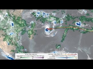
GPM IMERG precipitation rates and totals from Tropical Cyclone Freddy, Feb. 6 - March 12, 2023. Credit: NASA 

Download in high resolution from the NASA Goddard Scientific Visualization Studio

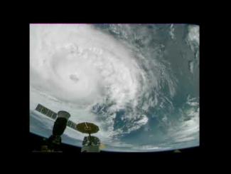
Cameras outside the International Space Station captured dramatic views of Hurricane Zeta at 12:50 pm ET October 28, as it churned 200 miles south-southwest of New Orleans packing winds of 90 miles an hour. Credit: NASA International Space Station

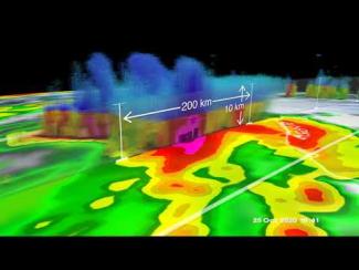
GPM overpass of Tropical Storm Zeta on October 25 at approximately 2:15pm CDT (19:15 UTC). Half-hourly rainfall estimates from NASA’s multi-satellite IMERG dataset are shown in 2D on the ground, while rainfall rates from GPM’s DPR instrument are shown as a 3D point cloud, with liquid precipitation shown in green, yellow and red, and frozen precipitation shown in blue and purple. Credit: NASA Goddard Scientific Visualization Studio

View an interactive 3D visualization of this overpass in STORM Event Viewer

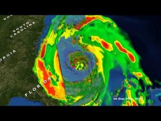
GPM captured Dorian at 10:41 UTC (6:41 am EDT) on the 4th of September when the storm was moving north-northwest parallel to the coast of Florida about 90 miles due east of Daytona Beach.  Three days earlier, Dorian had struck the northern Bahamas as one of the most powerful Category 5 hurricanes on record in the Atlantic with sustained winds of 185 mph.  The powerful storm to ravaged the northern Bahamas for 2 full days.  During this time, Dorian began to weaken due to its interactions with the islands as well as the upwelling of cooler ocean waters from having remained in the same location...

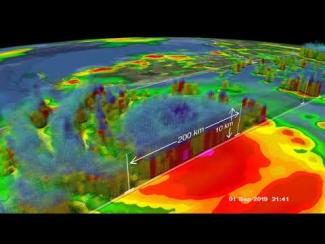
The Global Precipitation Measurement (GPM) Core Observatory captured these images of Hurricane Dorian on September 1st  (21:22 UTC) as the storm was directly over Abaco Island in The Bahamas.  At that time, the storm was a category 5 hurricane with maximum sustained winds of 185 mph (295 km/h) with gusts over 200 mph.

Hurricane Dorian on September 1, 2019 (21:22 UTC) over Abaco Island in The Bahamas

Visualizers: Kel Elkins (lead), Greg Shirah, Alex Kekesi

For more information or to download this public domain video, go to  https://svs.gsfc.nasa.gov/4751#27911

Hide Body

Hide Date