

IFloodS Campaign a Success
Monday, August 12, 2013
On a Wednesday afternoon in June, a severe storm outbreak spawned huge thunderstorms across Iowa and western Illinois. NASA's Polarimetric precipitation radar was in place to scan the storms as they swept through the region.
"It's unbelievable out here," Walt Petersen of NASA's Wallops Flight Facility in Virginia wrote in an email dispatch from Traer, Iowa. There, two NASA radars were stationed as part of the Iowa Flood Studies field campaign, which Petersen led, for the Global Precipitation Measurement, or GPM, mission.
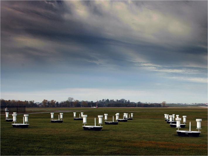 Caption: A cluster of rain gauges and soil moisture sensors deployed in Iowa during the IFloodS campaign.
Image Credit: Iowa Flood Center
"We caught a tornado outbreak," he said. "They are just marching by us, coming in about 30 to 50 kilometers away."
The Polarimetric, or NPOL, radar observed a number of distinctive hook features in many of the supercells, one only 25 miles (40 kilometers) to the north of the radars. The curved “hook” in storm clouds is produced by rain, hail or debris wrapped into the spinning center of the storm – a classic indicator for potential tornado production. In fact, tornadoes were spotted in and near several Iowa towns to the northwest of the radars.
"We had an extremely busy campaign," said Witek Krajewski, director of the Iowa Flood Center in Iowa City that partnered with NASA's GPM mission to run the Iowa Flood Studies, or IFloodS, experiment from May 1 to June 15. The effort included scientists from 10 research institutions. This year, it was a drastic change from the severe drought conditions of 2012. Rain showered eastern Iowa nearly every day, Krajewski said.
IFloodS was a ground validation field campaign designed to provide ground truth and interpret satellite measurements. "A lot of what we're trying to achieve here in IFloodS, is to connect everything we see from space, to what we see in the atmosphere and at the ground," Petersen said. IFloodS' goals were to evaluate satellite estimates of rainfall, and then see how well those estimates help predict flooding of Iowa's rivers.
Many current weather and research satellites have instruments that see rain from orbit. In 2014, NASA and the Japan Aerospace and Exploration Agency will launch GPM’s Core Observatory, which will be able to observe more detail and a broader range of precipitation types. One instrument will be able to better distinguish snow and ice from liquid rain, and its spaceborne radar will generate 3-D images of clouds and the precipitation inside.
It's a smorgasbord of satellite data that scientists need to interpret before they can put it to use in forecasting floods.
During this IFloods experiment, NASA and the Iowa Flood Center set up hundreds of rain gauges, soil moisture sensors, weather radars including NPOL, and other ground instrumentation to measure rainfall as accurately as possible across eastern Iowa. They then compared the ground measurements to observations made by satellites passing overhead.
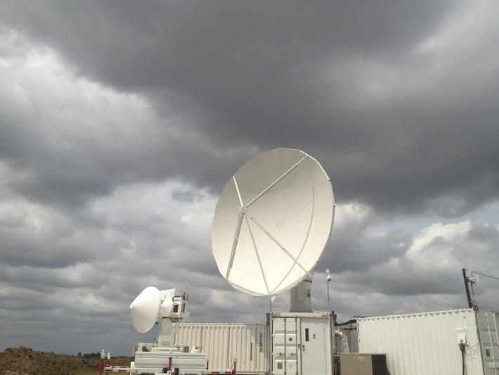 The NASA Polarimetric Radar (right) and Dual-Frequency, Dual-Polarimetric Doppler Radar (left) set up in field near Traer, Iowa.
Image Credit: NASA
The campaign began with a slushy surprise. "We came out to sample rain and we started out with a historic snowstorm," Petersen said. The May snow, the last gasp of a long winter, gave them a good case study for how snow and rain mix in a complex event. But soon the spring weather turned into just what they needed, a raining parade showing off everything from light drizzle to the fat drops from rolling thunderstorms.
The network of ground instruments and the advanced NASA weather radars took a very detailed look at the entire precipitation process, from ice particles at the top of a cloud melting into rain drops as they move to the bottom of the cloud and then sprinkle to the ground and into rain gauges. By understanding the details of the precipitation process in the field, the science team can fine-tune the methods they use to turn satellite observations into good rainfall measurements.
With six weeks of accumulated data, analyzing it all in detail will keep Petersen, Krajewski and their colleagues busy for the next year. From a first look at the data, “The results from the ground instruments and the orbiting satellites seem broadly consistent, but there are clearly some areas where we need to improve our understanding of what's going on,” Petersen said.
Once scientists have good rainfall measurements, then weather forecasters and others can use it. But the applications of the data go far beyond predicting the weather. NASA chose Iowa for its study site because of the presence of the Iowa Flood Center, its established network of monitoring instruments and its expertise in studying and predicting floods.
For floods, "large amounts of rainfall are a necessary ingredient," said Krajewski. During IFLoodS, large amounts of rainfall made an appearance, swelling rivers and causing flooding across the state. To forecast these damaging events, scientists also must understand factors including how the water moves through the soil and over the terrain as it makes its way into the river system. "It's a complicated phenomena and you have to have a good handle on these conditions to be able to make a good prediction."
Those conditions are loaded into computer models that simulate water movements, including whether it may inundate cities and towns. Good flood predictions are essential for warning systems and decision-makers. "Among the weather disasters in the U.S., flooding is second only to heat in the number of deaths, and it is number one in the dollar amount of damages," said Pedro Restrepo, hydrologist-in-charge of the National Weather Service's North Central River Forecast Center. In 2008, for example, flooding in the Midwest caused more than $10 billion in damages.
Worldwide, countries without weather radar or rain gauge networks are at even more of a disadvantage because they do not have strong warning systems. That’s why the GPM mission, with its precipitation observations covering 90 percent of the globe every three hours, is so important, Petersen said. The GPM Core satellite and its partner satellites can fill in the gaps in the ground network – in part, thanks to the work of the IFloodS team.
After a busy spring, Restrepo at the National Weather Service is looking forward to testing IFloodS data in their flood forecast models over the coming months. "Having the opportunity to participate in this experiment, and eventually having the opportunity to have the information from the satellite based GPM, will give us a considerable advantage for improving river flood forecasting."
For more information about the IFloodS campaign, visit: