storms

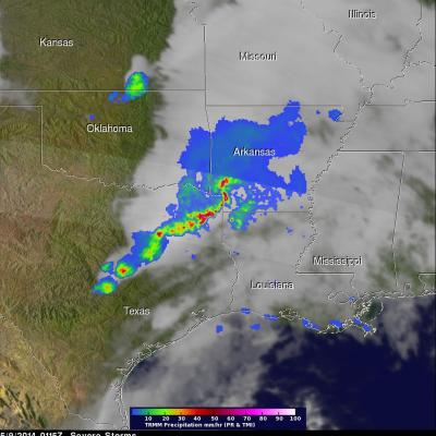
Slow-moving Frontal System Triggers Storms, Flooding Across Ohio Valley

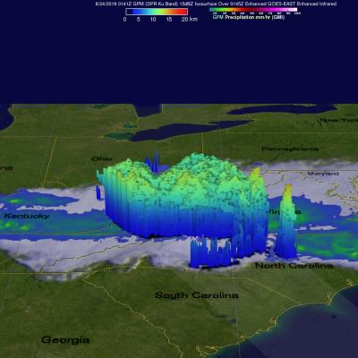
A slow-moving frontal boundary draped across the central US from the Central Plains across the Middle Mississippi and Ohio Valleys and into the Mid-Atlantic region has been providing the focus for numerous showers and thunderstorms the past few days while an associated East-West oriented, upper-level jet stream located near the front has helped to organize and strengthen the storms. This has lead to severe weather and flooding across the region. The latest episode began when thunderstorms formed and organized into a line across northern Illinois and southern Lake Michigan on the evening of

IMERG Analyzes El Niño Fueled California Storms

After a break in February, El Nino fueled storms have started pounding California as they move in from the Pacific Ocean. Northern California has been especially hard hit with heavy rainfall and strong winds being reported. Heavy rainfall north of Sacramento caused flooding that killed a woman in Olivehurst, California. Rain and snowfall in the Sierra Nevada mountains may help to alleviate the long lasting California drought. An analysis of total precipitation from February 29 to March 7, 1016 was accomplished using data collected by NASA's Multi-satellitE Retrievals for GPM (IMERG). This

TRMM Sees Stormy Bay Of Bengal

On May 19, 2014 at 1056 UTC TRMM flew over a tropical low (92B) in the Bay Of Bengal east of India. TRMM's Precipitation Radar (PR) instrument found that rain was falling at a rate of over 138 mm/hr (about 5.4 inches) in some strong convective storms. A rainfall analysis from TRMM's Microwave Imager (TMI) and Precipitation Radar (PR) data is shown overlaid on a METEOSAT-7 visible/infrared image captured at 1100 UTC . TRMM PR data were also used in this 3-D image that shows a simulated view of the tropical disturbance's rainfall structure. Tall storms were shown reaching heights of over 14km

Spring Storms Hit Great Plains

Severe weather was extending from Minnesota to southern Texas on Thursday afternoon and Friday morning. During that time there were three tornadoes reported in Minnesota, two in Colorado and two in Missouri. The TRMM satellite flew above tornado spawning thunderstorms in the southern United States on May 9, 2014 at 0115 UTC (May 8, 2014 at 8:15 PM CTD). A rainfall analysis from TRMM's Precipitation Radar (PR) and Microwave Imager (TMI) is shown overlaid on a GOES-EAST infrared image received at the same time. TRMM's PR instrument found rain falling at a rate of over almost 163 mm/hr (about 6.4

TRMM Observes Storm Moving From California Eastward

Images are routinely produced using TRMM Microwave Imager (TMI) data which show the global area covered by the satellite. These "Quick Look" images use Microwave brightness temperatures at 85.5 GHZ and at 37.0 GHZ combined in the red, green and blue components (guns) of the images. These false color images can be used to distinguish land from water and show the differences between land surfaces such as deserts, snow cover and sea ice. On these images areas of dry atmosphere over water appear as blue and moist atmosphere is dark blue. Snow cover over land appears as white or grey, deserts are