Julio

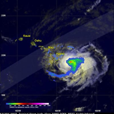
Tropical Storm Iselle Departs Hawaii While Julio Stays Well North

Iselle was once a rather powerful category 4 hurricane in the East Pacific with sustained winds estimated at 120 knots (~138 mph) by the National Hurricane Center. Fortunately, a combination of southwesterly wind shear, drier air and cooler waters weakened Iselle considerably as it approached the Hawaiian Islands. Although much weaker, Iselle still struck the southeast Kau coast of the Big Island of Hawaii as a rather strong tropical storm. In fact Iselle, was the strongest and only the 2nd tropical storm to hit the Big Island in over 50 years. The center made landfall around 2:30 am HST

Tropical Storm Iselle Hits Hawaii

Hurricane Iselle weakened to a tropical storm while approaching the island of Hawaii on Thursday August 7, 2014. As a tropical storm Iselle contained some heavy rain showers and strong winds when it hit the big island. Iselle later dropped some heavy rain over Maui and scattered showers extended to Kauai and Oahu. The TRMM satellite had an excellent view of tropical storm Iselle as it neared the Hawaiian islands on August 8, 2014 at 0152 UTC ( August 7 at 3:52 PM HST). A rainfall analysis from TRMM's Microwave Imager (TMI) and Precipitation Radar (PR) instruments is shown overlaid on a 0200

TRMM Sees Iselle and Julio Menacing Hawaii

The TRMM satellite saw both weakening hurricane Iselle and category two hurricane Julio in the same orbit as they were moving toward the Hawaiian islands on August 7, 2014 at 0922Z. This image shows data collected by TRMM's Microwave Imager (TMI) instrument with the orbit containing both hurricanes located in the center of the image. Microwave brightness temperatures at 85.5 GHZ and at 37.0 GHZ were combined in the red, green and blue components to construct the image. Recent forecasts of tracks for hurricane Julio and tropical storm Iselle are shown overlaid in white and red respectively.

Tropical Storm Julio Following Iselle's Track

The hurricane season in the eastern Pacific Ocean has been very active this year. Eleven named tropical cyclones have already formed in the eastern Pacific Ocean. Tropical storm Julio that formed yesterday is following almost the same path as hurricane Iselle toward the central Pacific and the Hawaiian Islands. The TRMM satellite flew over tropical storm Julio on August 5, 2014 at 0944 UTC and collected data used in these images. The first image shows a rainfall analysis derived from TRMM's Microwave Imager (TMI) and Precipitation Radar (PR) overlaid on an enhanced GOES-WEST image received at