

GPM Takes Rain Measurements Global
By Ellen Gray, NASA Goddard Space Flight Center
Original www.nasa.gov Feature (published 4/12/13)
Video Credit: Ryan Fitzgibbons
As anyone who has ever been caught in a sudden and unexpected downpour knows, gaps still exist in our knowledge about the behavior and movement of precipitation, clouds and storms. An upcoming satellite mission from NASA and the Japanese Space Agency aims to fill in those gaps both in coverage and in scientists' understanding of precipitation.
The Global Precipitation Measurement, or GPM, mission will set a new standard for precipitation measurements from space and it's doing so by joining forces with countries around the world, keeping not just one satellite's weather eye on the horizon, but nine.
"We need virtually continuous observation everywhere to construct a complete picture of precipitation around the globe, and that requires a lot of resources," says Arthur Hou, GPM project scientist at NASA's Goddard Space Flight Center in Greenbelt, Md. "Precipitation does not recognize national boundaries. It is in the best interest of every nation to pool resources together to make the best possible measurements through partnership."
For the GPM mission, NASA and the Japan Aerospace and Exploration Agency (JAXA) are joining forces with the space agencies of France and India, as well as the operators of meteorological satellites in Europe and the United States. The eight partner satellites on the mission are called the GPM constellation.
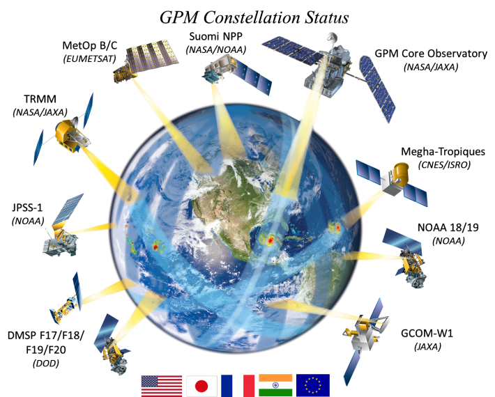 Illustration of the multiple precipitation measurement satellites which comprise the GPM constellation. Credit: NASA
"Each of the constellation members has its own scientific or operational objectives, but they all contribute data to GPM to create a unified global precipitation data product every three hours," says Hou.
At the center of this effort is the GPM Core Observatory, a satellite that will unify all the measurements from the constellation. The high quality measurements made by the GPM Core Observatory will serve as a reference standard for improving the accuracy of precipitation measurements made by other satellites.
Building on the success of the NASA and JAXA Tropical Rainfall Measuring Mission (TRMM), GPM carries two instruments. The GPM Microwave Imager (GMI) —provided by NASA—will estimate precipitation intensities from heavy rain, light rain and falling snow by carefully measuring the minute amounts of energy naturally emitted by precipitation. The Dual-frequency Precipitation Radar (DPR)—provided by JAXA—will make detailed measurements of three-dimensional rainfall structure and intensity. Together the two instruments will combine with the Core's near-global coverage of Earth and data from the constellation satellites to give a more complete picture of global precipitation.
Pole-to-Pole Coverage
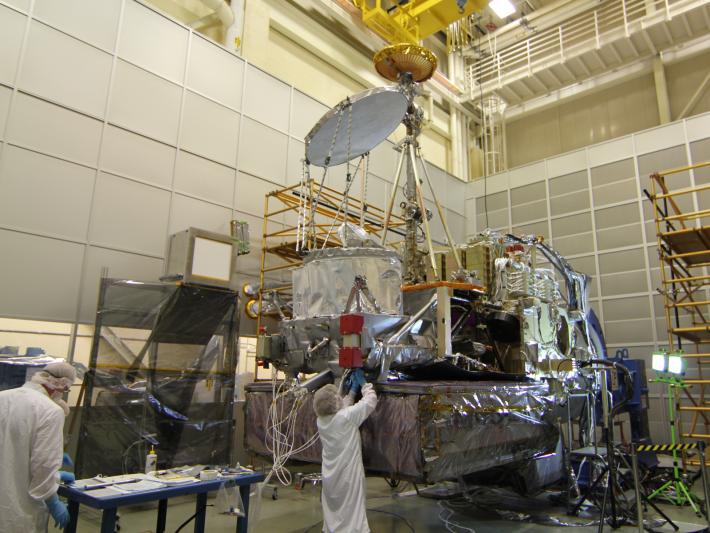 The GPM Core Observatory is being built and tested at Goddard Space Flight Center. The silver disc and drum (center) is the GPM Microwave Imager, built by Ball Aerospace Corp, in Boulder, Colo. The large blocks on the base is the Dual-frequency Precipitation Radar, built by JAXA. The tall golden antenna is the High Gain Antenna for communications. Credit: NASA
GPM's predecessor, the TRMM satellite, revolutionized scientists' view of precipitation with its highly sensitive and high-resolution observations. But TRMM was designed to measure moderate to heavy rainfall over the tropics, from 35 degrees latitude North and South of the equator. Most of Europe, the northern portion of the United States, Canada, and Japan are outside of TRMM's view. When launched, GPM's coverage will expand beyond TRMM's into those mid and high latitudes. Its orbit from 65 North to 65 South will mean measurements of precipitation across 90 percent of Earth's surface, from about the Arctic Circle to the Antarctic Circle.
Expanding coverage also means expanding the types of precipitation that GPM will measure, most notably light rain and snowfall. They account for about half of the precipitation in temperate mid-latitudes and cold high latitudes and are major contributors to freshwater resources in places like the United Kingdom and northern Europe, the southern Appalachian Mountains and the snow packs of the Rocky Mountains and the Sierra Nevada.
Measuring snow and light rain from space is a technical challenge because of their small size, and the multitude of shapes of ice crystals, says Gail Skofronick-Jackson, GPM's deputy project scientist at NASA Goddard and a specialist in detecting snow from space.
The advancements on the GMI radiometer include an increased sensitivity to light rain and for the first time snowfall, and the two radar channels on the DPR will provide information on the size and shapes of raindrops and snowflakes, which will improve estimates of how much water they hold. "We're very excited about this new capability," says Skofronick-Jackson.
The new data on light rain and snow, like all the measurements GPM will make, won't just affect the weather forecast. They will also improve what climate modelers can say about the distribution of rainfall in the coming years. "As the Earth's temperature warms, most models predict that we'll have more heavy rain events, but they disagree on whether we'll have more or less light rain," says Hou. "GPM data will help us to clarify that."
A Song of Water and Heat
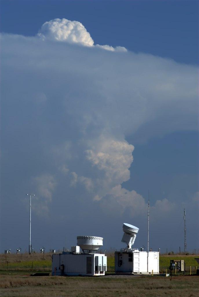 Storms over the cloud radars during the Mid-latitude Continental Convective Clouds Experiment. This experiment from April 22 to June 11 was part of the GPM missions ground validation program, where teams of scientists take very detailed measurements of rainfall and storm systems on the ground and compare them to measurements made by radars and radiometers similar to those that will fly on the Core Observatory. Credit: DOE/ARM/Scott Collis
As part of Earth's climate system, precipitation tells us about the ways energy moves around the planet. Hou says energy and precipitation are connected through the process of how water vapor in the atmosphere is converted into liquid or ice particles that make up clouds, rain and snow.
This process releases heat energy, called latent heat, into the atmosphere. You can see this happening in thunderstorm clouds; the release of heat causes air masses to rise and grow upward in a tall, billowing shape. This vertical movement of air masses creates pressure changes and wind -- ultimately influencing how large-scale winds circulate and transport heat around the globe, which then affects local climate.
Precipitation at Earth’s surface is the signature of the total latent heat released throughout an atmospheric column above it. Scientists will use the combined moisture information from the GMI with the DPR's three-dimensional images of precipitation to get a better understanding of the mechanisms and behavior of latent heat structures that evolve with clouds and precipitation.
Now Presenting: Rain in 3D
Studying latent heat in storms dovetails with the direct need to study storm behavior, especially of hurricanes and tropical cyclones that can have devastating effects in terms of flooding, landslides, economic damage and loss of life.
The first space-borne precipitation radar on the TRMM satellite changed the way scientists understood storms. Its single radar frequency provided a new three-dimensional view of how systems like hurricanes grow and intensify as they move through the tropics. When the GPM Core observatory satellite launches, its DPR will have a second radar frequency that will not only add precision, but will also give scientists the ability to infer the microphysical processes that govern rain droplets and snowflakes within storm systems, including the process of condensation that produces latent heat. Additional heat accumulating high up in a storm is one of the signs that it's about to intensify, which is valuable information for forecasters.
Even more valuable will be the ability to continue to observe intense storms, like Superstorm Sandy, which devastated the New Jersey and New York coasts in Oct. of 2012, as they move north or south into the middle and higher latitudes. The GPM Core's expanded coverage will give scientists a window into understanding how individual storms like Sandy intensify and change over the course of their entire life cycles.
"Satellite data are already being used operationally to improve weather forecasts," says Hou. "GPM data will be of much higher quality and that will enable the operational agencies to continue to improve their forecast products."
GPM will also be used to improve other computer models, including those for understanding and predicting climate, floods, watershed hydrology, and crop forecasting. One of the moving parts they each depend on is accurate and frequent observations of rain, sleet, hail, snow and other forms of precipitation. Global GPM data will be part of fitting the puzzle pieces together.
"When most people start a puzzle, they do the edge pieces first. Other satellites have started that, but the GPM Core is really poised to complete the boundaries so we can understand how liquid rain and frozen precipitation fall out of clouds," says Skofronick-Jackson. The constellation observations fill in the rest of that puzzle, she says, "so that we have a complete understanding both scientifically and structurally of precipitation so we can apply it to all sorts of applications."
The GPM Core Observatory, the largest satellite to be built and tested at Goddard, will be transported from Maryland to Tanegashima Island in Japan where it will launch on a Japanese H-IIA rocket in early 2014.
Video Text: